NY awarded $32M for Safe System road upgrades. See what it means for safer corridors, faster housing approvals, and modern infrastructure planning.
$32M for Safer NY Roads: What It Means for Growth
$32 million doesn’t sound like “transformational” money when you’re talking about highways, bridges, and multi-year capital plans. But targeted safety funding can punch above its weight—because it’s aimed at the places where crashes actually happen and where design fixes work fast.
On December 10, 2025, New York State announced more than $32 million awarded to local governments to enhance roadway safety using a Safe System approach—an explicit commitment to building roads that are designed for human mistakes, not perfect behavior. That matters for every community trying to do two big things at once: support housing growth and modernize transportation networks without paying the hidden “tax” of traffic deaths and serious injuries.
This post breaks down what this investment signals, what a Safe System approach looks like on the ground, and how local leaders, developers, and infrastructure partners can turn safety dollars into long-term capacity for growth.
The real story behind the $32M: speed, design, and accountability
This funding is fundamentally about one thing: reducing fatal and severe crashes by changing street conditions, not just issuing more reminders to “drive carefully.” The Safe System approach treats deaths on state highways as preventable outcomes of design, speed, and conflict points.
Here’s the stance I agree with: if a roadway routinely produces fatalities, the roadway is failing. Drivers make mistakes. Kids cross at the wrong time. A person looks down at a phone. The system has to assume that—and still keep people alive.
A Safe System program usually prioritizes projects that do at least one of the following:
- Reduce vehicle speeds where people walk, bike, or turn frequently
- Separate conflicting movements (turning cars vs. crossing pedestrians)
- Make night driving safer with lighting, reflectivity, and clearer guidance
- Improve intersections, where a large share of severe crashes occur
This is also a governance story. Awards to local governments push safety decisions closer to the street level—where the problem is visible and the fix can be measured.
Why this matters in late 2025 (and going into 2026)
End-of-year announcements aren’t just press cycles—they often align with project pipelines that get scoped in winter and bid in spring. Communities that are ready with designs, permitting, and right-of-way clarity tend to move first.
There’s also a practical seasonal point: winter driving exposes weaknesses—faded markings, poor lighting, confusing merges. The projects funded now can be shaped around what failed during the last storm season.
Safe System, explained like you’ll actually use it
Safe System can sound like policy jargon. It’s not. It’s a design philosophy with a blunt premise: people will make mistakes, and roads should be forgiving enough that mistakes aren’t fatal.
The approach typically rests on a few core ideas:
- Safe speeds: The faster the speed, the less survivable the crash.
- Safe roads: Geometry, crossings, and materials reduce conflict and severity.
- Safe vehicles: Technology helps, but it can’t compensate for bad design.
- Safe road users: Education and enforcement still matter, just not alone.
- Post-crash care: Faster detection and response improves outcomes.
The shift is this: the default response to crashes becomes engineering + systems management, not just blaming individual behavior.
What “toward zero deaths” looks like in project terms
Zero is an ambitious goal, and people love to debate it. I’m firmly on the side that it’s the right target because it changes decision-making.
When “zero deaths” is the goal, you prioritize projects differently:
- High-injury networks first (corridors where severe crashes cluster)
- Intersections before long segments (because conflicts concentrate there)
- Speed management before signage (because speed drives severity)
- Simple, durable treatments (because maintenance is real life)
A Safe System approach also pushes agencies to measure outcomes that matter:
- Fatalities and serious injuries (KSI)
- Speed compliance and operating speeds
- Near-miss indicators where available (e.g., conflicts at crossings)
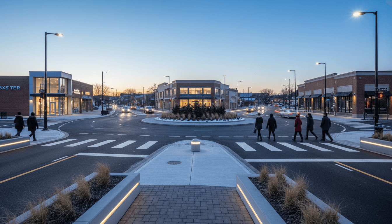
Where the money usually goes: the short list of high-impact safety upgrades
Even without a project-by-project list in front of us, roadway safety awards to local governments commonly fund a familiar set of treatments—the ones transportation engineers reach for because they’re proven and buildable.
Intersection fixes (the highest ROI in many communities)
Intersections are crash factories when they’re oversized, too fast, or too complex.
Common Safe System intersection upgrades include:
- Roundabouts (often reduce severe-angle crashes)
- Protected left-turn phases or turn restrictions where warranted
- Signal timing and visibility upgrades to reduce red-light running and confusion
- Raised intersections or tighter curb radii to slow turning speeds
If your community is planning new housing near an arterial, this is where to look first. A few corrected intersections can change whether a corridor can handle more residents safely.
Safer crossings for people walking and biking
Housing growth only works when people can cross the street without gambling.
Typical safety investments include:
- Rectangular rapid-flashing beacons (RRFBs) or upgraded pedestrian signals
- Median refuges so crossings can be done in two stages
- Shorter crossing distances via curb extensions
- Protected bike lanes or separated facilities in higher-speed contexts
A practical rule I use: if you’re adding housing near a high-speed road, you need to budget for the crossing environment—not just the driveway permit.
Speed management (the uncomfortable but necessary one)
Many local governments still try to solve speed with signs. It rarely works.
Safe System speed management usually means:
- Lane narrowing or road diets where appropriate
- Gateway treatments at town/village entries
- Horizontal deflection (curves, chicanes) on problem segments
- Automated or targeted enforcement paired with design changes
The goal isn’t to make driving miserable. It’s to make the safe choice the easiest choice.
Lighting, markings, and “boring” visibility work
These are the projects residents don’t photograph—but they save lives, especially during winter darkness.
- Upgraded LED lighting at crossings and intersections
- High-contrast markings and reflective elements
- Clearer lane guidance through merges and curve segments
If you’re trying to modernize transport networks, don’t skip the basics. A smart corridor with bad visibility is still a dangerous corridor.
Safety spending is housing-and-infrastructure spending (whether we admit it or not)
This post sits in our Housing & Infrastructure Development series for a reason: road safety is a precondition for building places people actually want to live.
When safety is ignored, housing projects face predictable blowback:
- Neighbors oppose density because traffic feels dangerous
- Schools and parents demand costly, last-minute fixes
- Emergency response routes become politically sensitive
- Projects get delayed by “we’ll fix it later” promises that nobody trusts
When safety is baked in early, you get the opposite:
- More support for infill and mixed-use projects
- Better access to transit stops and community services
- A clearer path for complete streets and safer corridors
Here’s the reality: a safe corridor increases the usable value of adjacent land. It’s not just a transportation outcome; it’s an economic development outcome.
A simple example: the corridor that blocks new housing
You’ve seen this pattern.
A town wants 300 units near a commercial strip. The strip is a state route with fast traffic, few crossings, and turning chaos at peak hours. The housing plan may be fine on paper, but the lived experience is unsafe.
A Safe System project that adds a protected crossing, reduces turning speeds, and clarifies movements can turn that strip from a barrier into a connector. That’s how small safety projects unlock larger housing capacity.
How local governments can turn safety grants into long-term delivery capacity
Winning funding is good. Delivering a project that meaningfully cuts severe crashes is better. The communities that get the most value tend to operate with a repeatable playbook.
1) Start with the high-injury network, not the loudest complaint
Resident feedback matters, but severe crashes cluster, and data should lead.
A practical prioritization stack:
- Corridors with fatal/serious injury history
- Intersections with recurring angle/turning crashes
- School zones and senior destinations with exposure risk
- Locations with speed noncompliance above design intent
2) Choose treatments that match the context
A Safe System approach isn’t “always add a bike lane” or “always add a roundabout.” It’s choosing interventions that reduce conflict and severity for the users actually present.
- Rural highways need different strategies than village main streets.
- Freight corridors need turning and lane guidance that doesn’t create new hazards.
3) Design for maintenance and winter operations
If striping vanishes every February, it’s not a safety feature—it’s a suggestion.
Buildability questions that should be answered up front:
- Will plows hit it?
- Who maintains it, and with what budget?
- Does it still function in darkness and rain?
4) Measure outcomes people can understand
Public trust rises when agencies report simple, meaningful metrics:
- Operating speed before/after
- Number of severe crashes before/after (multi-year trend)
- Yield rates at crossings
- Conflict reduction at key intersections
If you can’t measure it, you can’t defend it when budgets tighten.
Practical next steps for partners (planners, developers, and builders)
This funding wave is a signal to the market: safety is becoming a core expectation of infrastructure modernization.
If you’re a planner or municipal leader:
- Map your high-injury corridors and align them with your housing growth areas.
- Keep a “shovel-ready safety shelf” of 3–5 projects with completed concepts.
If you’re a developer or property owner:
- Treat off-site safety upgrades as part of feasibility, not a surprise cost.
- Bring a corridor safety concept to early meetings—communities respond well to seriousness.
If you’re an engineering, construction, or materials partner:
- Offer value around constructability, winter resilience, and quick-build options.
- Focus on treatments that reduce conflict points and speed-related severity.
A modern transportation network isn’t the one with the most lane miles. It’s the one that moves people without killing them.
Road safety funding like New York’s $32 million Safe System investment should be read as infrastructure modernization in its most human form: making everyday movement survivable and predictable.
If 2026 is a year of housing delivery and corridor upgrades in your community, the smartest move is to treat safety as the foundation—then build density, mobility, and economic growth on top of it. What would change in your town if the most dangerous mile of roadway became the safest?