Piparo’s mud volcano highlights why AI monitoring matters in T&T. Learn how early-warning systems and automation can reduce risk for energy and oil & gas operations.
AI Monitoring for Piparo Mud Volcano Risk in T&T
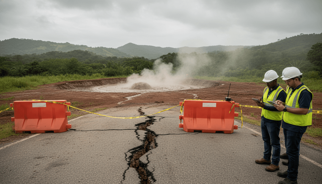
On Christmas morning in Piparo, the most practical question wasn’t “Will the mud volcano erupt again?” It was, “If it does, can we get out?” When roads crack, water lines rupture, and the ground keeps shifting, “monitoring” stops being a scientific exercise and becomes a basic public-safety requirement.
That’s why the Piparo mud volcano activity this week is bigger than a local news story. It’s a clear, close-to-home example of a problem Trinidad and Tobago’s energy and oil & gas sector already lives with: high-consequence operations in a geologically active, infrastructure-sensitive environment. The reality? Most organisations still treat geohazards as periodic reports instead of continuous signals.
This post uses Piparo as a case study and shows where AI monitoring and automation fit: early warning, faster response, better decisions, and fewer “we didn’t see it coming” moments—whether you’re responsible for a community road or a critical access route to an energy asset.
What Piparo is really telling us about risk
Answer first: Piparo shows how quickly small geological changes become operational emergencies when monitoring, access, and utilities aren’t instrumented for real-time decision-making.
According to reports from residents and officials, at least five homes were affected after the volcano rumbled on December 24, with hot mud, smoke, new cracks appearing near homes, and major road fractures that made routes impassable. One family—living in a two-storey, seven-bedroom house with children and elderly parents—spent Christmas monitoring changes in the ground and listening for changes in sound from the volcano.
A line in the reporting hits hard: the household was out of water because the main line ruptured due to land movement. That’s the chain reaction in plain language:
- Ground movement → ruptured utilities
- Utility failure + blocked roads → reduced ability to shelter in place
- Reduced mobility → higher evacuation risk
- Uncertainty → slower, more stressful decisions
Piparo also has memory. There was heightened activity in 2019 and a major eruption in 1997 that forced evacuations. This isn’t a “never happened before” scenario. It’s a reminder that known hazards deserve modern monitoring—and that monitoring has to feed into response, not sit on a shelf.
The hidden problem: “quiet” can be the scariest signal
Residents described periods where the volcano was “a bit quiet,” with noises lessening but cracks still appearing. Anyone who manages safety systems knows this feeling: less obvious activity doesn’t always mean less risk. Sometimes it means pressure is shifting elsewhere.
This is exactly where AI helps. Not by guessing, but by detecting patterns across many weak signals at once—signals that humans can’t realistically track 24/7.
Why AI monitoring matters for oil & gas in Trinidad and Tobago
Answer first: The same geohazard dynamics that threaten homes and roads in Piparo can threaten energy operations—access roads, pipelines, well pads, tank farms, and power/telecom links—and AI improves detection and response speed.
In Trinidad and Tobago, energy operations depend on reliable access and stable ground. When the ground shifts, the first failure is often not the “asset” itself. It’s the supporting network: roads, culverts, water lines, and communications—exactly what Piparo residents are dealing with.
Here’s the stance I’ll take: if your emergency response depends on someone noticing cracks or hearing rumbling, you’re already late. Modern risk management means turning the environment into measurable data.
What “AI monitoring” actually means (without buzzwords)
AI monitoring in the geohazard context is usually a combination of:
- Sensors (ground vibration, tilt, strain, pressure, gas)
- Remote sensing (satellite radar such as InSAR for ground deformation, drones for imagery)
- Data pipelines (cleaning, time-syncing, alert routing)
- Machine learning models (anomaly detection, trend forecasting, event classification)
- Decision workflows (who gets alerted, what thresholds trigger actions, what gets shut down)
AI is strongest at two things that matter in crises:
- Detecting “abnormal” early from noisy, messy inputs
- Prioritising response so teams don’t waste time chasing false alarms
A practical AI early-warning blueprint for Piparo-like hazards
Answer first: A workable early-warning system combines low-cost sensors, satellite deformation tracking, automated alerts, and clear response thresholds tied to actions.
If you were building a serious monitoring and automation plan for Piparo—or for an energy operator managing geohazard exposure—you wouldn’t start with a massive control room. You’d start with coverage, reliability, and actionability.
Step 1: Instrument the ground where failure is most expensive
Focus on places where movement causes cascading disruption:
- The access road(s) and known crack zones
- Utility corridors (water mains, telecom trenches)
- Areas near homes, schools, and community facilities
- Any critical infrastructure alignments (pipelines, rights-of-way, culverts)
Recommended baseline kit (typical components):
- Low-power seismometers or vibration sensors
- Tiltmeters/inclinometers near crack edges
- Strain gauges on key road segments or bridges
- Weather sensors (rainfall can correlate with slope and soil behaviour)
Step 2: Add satellite monitoring for wide-area ground deformation
Satellite radar deformation monitoring (often discussed as InSAR) is particularly useful because it can detect subtle uplift/subsidence patterns over time.
For Trinidad and Tobago, this matters because ground movement isn’t always dramatic. Slow deformation over days or weeks can be the prelude to sudden failure—like a road giving way.
Step 3: Use AI for anomaly detection, not “perfect prediction”
The goal isn’t a Hollywood-style prediction of an eruption time. The goal is:
- Identify when today is not like last week
- Flag where movement is accelerating
- Correlate signals (vibration + tilt + new cracks + gas readings)
A solid approach is unsupervised anomaly detection because labelled “eruption” datasets are limited. You train models on “normal” behaviour and alert on deviation.
Snippet-worthy truth: Early warning is mostly anomaly detection with good operations behind it.
Step 4: Turn alerts into decisions with pre-agreed thresholds
Alerts that don’t trigger actions create fatigue and distrust. The fix is simple: tie each alert level to a playbook.
Example structure:
- Advisory: unusual readings; increase inspection frequency; notify local disaster management
- Watch: movement accelerating; restrict heavy vehicles; stage barriers and water tankers
- Warning: rapid deformation or correlated signals; evacuate defined zones; close roads; isolate utilities where needed
For energy operators, the same idea applies:
- Advisory → increase patrols / drone flyovers
- Watch → restrict access, reduce operating envelope
- Warning → temporary shutdown, isolate sections, activate incident command
Faster crisis response: where automation earns its keep
Answer first: Automation reduces response time by routing the right information to the right people and pre-positioning resources before conditions deteriorate.
In the Piparo story, officials visited, assessed, and made commitments—rehabilitating roads, restoring water, managing access restrictions. That’s necessary. But during fast-changing conditions, the biggest enemy is time.
Here are response areas where automation makes a measurable difference:
Automated situational awareness
Instead of relying on scattered updates:
- A single dashboard shows road status, sensor health, and active crack reports
- Residents’ reports (calls, forms, WhatsApp tips) can be triaged using AI text classification
- Drone imagery can be compared over time to quantify crack growth
Utility protection and rapid restoration
When water mains rupture due to land movement, restoration becomes harder if the ground is still shifting.
AI can help by:
- Predicting likely rupture zones based on deformation patterns
- Prioritising repair crews and equipment
- Recommending temporary supply actions (tankers, standpipes) based on demand estimates
Safer access management
When roads are cracking, “just drive carefully” isn’t enough.
A more robust approach:
- Dynamic road closures based on sensor thresholds
- Automated rerouting suggestions for emergency vehicles
- Weight limits triggered by movement rates (heavy trucks accelerate failure)
What energy leaders in T&T should do next (even if Piparo isn’t your asset)
Answer first: Use Piparo as the prompt to formalise an AI monitoring program for geohazards—starting with a pilot, clear KPIs, and cross-agency response workflows.
If you’re in the energy and oil & gas sector, you don’t need to “own” the Piparo problem to learn from it. You need to recognise the pattern: geology + infrastructure + people + time pressure. That pattern exists across operations.
A practical 90-day pilot plan
Here’s what works when organisations want progress without paralysis:
- Pick one high-risk corridor (access road to a facility, pipeline segment, or slope-prone area)
- Deploy a minimal sensor stack (vibration + tilt + rainfall) and establish a data pipeline
- Add satellite deformation snapshots on a fixed schedule
- Build an anomaly baseline (what “normal” looks like over 4–8 weeks)
- Define response thresholds with operations, HSE, and security in the same room
- Run one table-top exercise using simulated alerts
KPIs that actually matter
Avoid vanity metrics like “number of sensors.” Measure outcomes:
- Alert-to-action time (minutes)
- False alarm rate (and why)
- Road/asset downtime avoided (hours)
- Incident escalation prevented (count)
- Cost of monitoring vs. cost of disruption (TT$)
If you can’t link monitoring to operational decisions, it’s not a safety program—it’s a science project.
Where this fits in our AI-in-energy series
This post sits at the “front end” of AI transformation: AI for risk sensing and response, not just AI for reporting or content.
Piparo’s mud volcano activity is a reminder that Trinidad and Tobago’s energy competitiveness isn’t only about production. It’s about resilience—keeping people safe, protecting infrastructure, and maintaining continuity when the ground decides to move.
If your organisation had real-time geohazard monitoring and automated response playbooks in place, what would you do differently the next time a road starts cracking—wait for daylight, or act on data within minutes?