AI field setup gets easier when trusted boundaries sync instantly. See why TerraClear’s integration improves mapping accuracy and reduces manual work.
AI Field Setup Made Easy: Boundaries Sync in Seconds
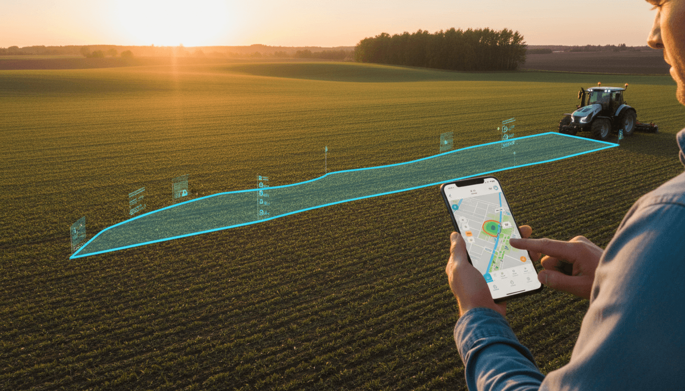
Field boundaries are “small data” that quietly controls a lot of money. If your boundary map is off by even a few meters, that error ripples into planting, spraying, scouting routes, variable-rate prescriptions, and ultimately the quality of your yield records.
That’s why the recent TerraClear integration with John Deere Operations Center matters. Not because it’s flashy—but because it removes one of the most common (and most frustrating) blockers in precision agriculture adoption: getting clean, trustworthy field boundaries into a new tool without a day of file exporting, shapefiles, and manual cleanup.
This post is part of our series “አርቲፊሻል ኢንተሊጀንስ በእርሻና ግብርና ዘርፍ ውስጥ ያለው ሚና”—and it fits perfectly. Because AI in agriculture isn’t only about big predictions. A lot of the real value shows up when AI-compatible systems reduce friction, automate data hygiene, and make precision workflows realistic for busy growers.
The real bottleneck in precision farming isn’t hardware
The bottleneck is setup friction.
Most farms don’t struggle to understand why precision farming is useful. They struggle with the first 60 minutes of using a new tool—when they’re forced to:
- Find the latest field boundary files on a laptop
- Export or convert formats (often using GIS tools that nobody wants to open)
- Email files to themselves or move them with USB drives
- Re-label fields, fix duplicates, and rebuild exclusion zones
That onboarding work is invisible on marketing brochures, but it’s where many tech pilots die.
TerraClear’s new integration targets that exact failure point by letting farmers pull their existing field boundaries directly from John Deere Operations Center into the TerraClear mobile app. No exports. No shapefiles. No “send me the right file.”
If you care about AI-driven agriculture, this matters because AI systems are only as good as the base map they operate on. A rock-picking robot, a weed-detection model, or a pest scouting workflow needs reliable geospatial context. Boundaries are that context.
What the TerraClear–Operations Center integration actually changes
The change is simple: verified boundaries move from an existing trusted system to a new mobile tool in seconds.
TerraClear’s announcement describes a direct-to-mobile connection where farmers log in, select their organization, and sync their boundary library quickly—bringing in field names, IDs, and exclusion zones.
Why “direct sync” beats file exports
Direct sync is better than exporting files for one reason: it keeps the map source-of-truth consistent.
File-based workflows create copies. Copies create drift.
One person exports boundaries in March. Someone edits a boundary in May. A service provider imports the March file in June. Now the farm has multiple “correct” maps floating around. That’s how you end up with mistakes like:
- Spraying slightly outside the intended area
- Equipment guidance lines not matching actual borders
- Service orders mapped to outdated field IDs
- AI scouting outputs that don’t align with your records
Direct integration reduces that drift by pulling boundaries from the place growers already manage them.
Automatic data cleaning: the quiet win
TerraClear also highlights an automatic data clean step—detecting duplicates and keeping the most up-to-date field values.
That sounds small, but it’s a big deal operationally. Duplicate boundaries are one of the most common reasons teams lose trust in digital maps. Once someone sees “Field 12” and “Field 12 (1)” and “Field 12_NEW,” confidence drops fast.
A practical rule I’ve found in farm digitization projects is:
If your data needs a weekly “map babysitter,” you don’t have a tech stack—you have a recurring headache.
Automated cleanup pushes precision farming closer to what it should be: a system that maintains itself.
Why field boundaries are the backbone of AI in agriculture
Field boundaries are foundational because they tell every system one critical thing: where work starts and stops.
AI in agriculture often gets framed as models that “see” crops or predict yield. In reality, many AI workflows start with something more basic:
- Define the area of interest (the field boundary)
- Collect or ingest data (imagery, machine data, scouting notes)
- Clean and reconcile data (dedupe, align IDs, handle exclusion zones)
- Generate an action (task map, service order, robot mission)
If Step 1 is wrong, everything after it becomes questionable.
Mapping accuracy isn’t a “nice-to-have”
When boundaries are accurate and consistent:
- Your AI scouting results are assigned to the correct field
- Your service provider tasks match your records
- Your analytics dashboards show the right hectares and yield
- Your robotics missions avoid no-go zones and sensitive areas
When boundaries are messy:
- Output looks “off,” even when the AI is correct
- Operators override the system manually
- Teams stop trusting the platform
So yes—syncing boundaries is not glamorous. But it’s exactly the type of workflow improvement that makes AI-powered farming usable at scale.
A practical walkthrough: what “seconds” should look like on real farms
The integration described includes secure authentication, one-click sync, and automatic deduping. Here’s how to think about it in a real farm context—especially if you’re evaluating tools during year-end planning (which many farms do in late December).
Step-by-step onboarding checklist (what to test)
If you’re trialing TerraClear or any AI-compatible mapping tool, test onboarding like a process, not a demo.
- Login time: Can your admin authenticate without creating a new account system?
- Org selection: If you manage multiple entities, can you choose the right one easily?
- Boundary import completeness: Do field names, IDs, and exclusion zones come across cleanly?
- Duplicate handling: If duplicates exist, does the system resolve them in a way you agree with?
- Field verification in the yard: Can you open the map on a phone and confirm it matches what operators see?
A tool that passes these five checks is far more likely to survive the season.
What to prepare before you sync
You don’t need GIS skills, but you do need discipline. Before syncing boundaries into any new platform:
- Decide who owns boundary edits (one person or one small team)
- Standardize field naming (avoid “new,” “final,” “final2”)
- Confirm exclusion zones are up to date
This is basic data governance—unsexy, but it’s what makes AI adoption stick.
Where TerraClear fits in the bigger AI-and-automation trend
TerraClear is known for using AI and robotics to handle labor-intensive jobs—starting with rock picking, a task many growers genuinely dislike. The company notes that annual rock emergence impacts nearly half of North American farms, contributing to equipment damage and downtime.
That background matters because it shows the bigger pattern:
- Imagery becomes an actionable map
- AI identifies the problem (rocks today, weeds/pests/disease tomorrow)
- Robotics or field operations execute the task
But none of that works smoothly if the digital field setup is painful.
The broader trend: “AI-compatible” beats “AI-only” tools
A lot of agriculture tech fails because it acts like it’s the center of the universe. Farms don’t want another isolated app. They want tools that connect to what they already use and trust.
In practice, AI in agriculture wins when it:
- connects to existing farm management platforms
- reduces manual steps
- keeps datasets consistent across systems
- turns insights into field actions
Integrations like this one signal that the market is maturing: the goal is no longer “collect more data.” The goal is make trusted data usable everywhere.
Common questions growers ask about boundary syncing (and straight answers)
“Will this really save time?”
Yes—because the time isn’t only in exporting files. The real time sink is fixing errors after import. Direct syncing plus deduping removes a lot of rework.
“Does it matter if my boundaries are already ‘pretty good’?”
It matters because “pretty good” boundaries can still break automation. Robots, variable-rate tools, and AI scouting outputs rely on consistent geofencing. Small inaccuracies become operational issues when machines are following maps.
“Is this ‘AI,’ or just software integration?”
It’s both in the way that counts. AI-driven agriculture depends on clean data pipelines. Integration is the pipeline; AI is the engine. If the pipeline is broken, the engine can’t help you.
“What should I measure after implementing this?”
Track practical metrics, not hype metrics:
- Minutes to onboard a new operator or agronomist app
- Number of boundary-related support tickets per season
- Duplicate fields detected per import
- Percent of service orders that match correct field IDs
Those are the indicators that AI and precision farming are actually becoming easier to run.
What to do next if you’re planning for the 2026 season
Late December is when many farm teams evaluate tools, budgets, and workflows for the next season. If AI in agriculture is part of your plan, put field setup and data reliability at the top of the list—right next to hardware.
Here’s a practical next step:
- Audit your current boundary library (names, IDs, exclusion zones)
- Choose one “system of record” for boundaries
- Favor tools that connect directly to that system and clean duplicates automatically
Because the farms that get the most value from AI aren’t the ones with the most sensors. They’re the ones with the cleanest, most usable data.
As this series—“አርቲፊሻል ኢንተሊጀንስ በእርሻና ግብርና ዘርፍ ውስጥ ያለው ሚና”—keeps showing, AI’s role is often practical: reduce manual effort, increase confidence in decisions, and make modern agribusiness easier to operate day after day.
If your 2026 goal is more automation—rock management, weed control, scouting, or smarter service orders—start with this question: Are your field boundaries clean enough that you’d trust a machine to follow them?