Violent underwater storms beneath Antarctic ice are speeding melt and sea-level rise. Here’s how AI and green technology can keep our plans realistic.
Most coastal cities are planning for around 1 to 3 feet of sea-level rise by 2100. The ice sheet sitting on West Antarctica alone holds enough water to raise seas by about 10 feet.
That gap between what’s planned and what’s possible is why this new research on violent underwater “storms” beneath Antarctica’s ice shelves really matters — not just to climate scientists, but to anyone building green infrastructure, clean energy projects, or climate-resilient businesses.
Here’s the thing about these storms: they’re invisible from space, driven by tiny changes in salinity and temperature, and they can reshape ice on timescales of days to weeks. If we care about designing smart, climate-safe systems, we need to understand what’s happening under that ice — and how modern sensing, AI, and green technology can keep up.
This article walks through what these storms are, why they accelerate Antarctic ice loss, and how a new wave of sensors, robotics, and AI-driven climate models can help governments and companies make better decisions right now.
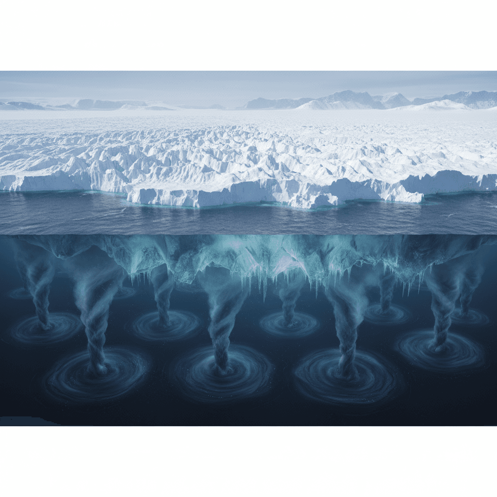
What are these underwater “storms” under Antarctic ice?
Under Antarctica’s floating ice shelves, the ocean isn’t calm. It’s more like a hidden weather system.
Researchers have shown that as ice shelves melt and refreeze, they trigger dense, spinning vortices in the ocean beneath them — essentially mini-storms made of water instead of air. These storms:
- Form when sea ice freezes and ejects salt, making surrounding water heavier
- Intensify when fresh meltwater from ice shelves lightens nearby water
- Create strong vertical mixing, pulling relatively warm deep water upward
That vertical stirring is the problem. Ice shelves normally sit on a thin cushion of near-freezing water that insulates them from deeper warmth. The storms punch through that “cold blanket” and drag up warmer water that chews away at the underside of the ice.
Scientists running advanced ocean–ice models found that these vortices aren’t rare quirks. They’re a recurring feature of the West Antarctic coastal ocean — small in size, but powerful in impact.
One way to picture it: every time the ice breathes — freezing, melting, shedding freshwater — it kicks the ocean, and the ocean kicks back.
How these storms speed up ice loss and sea-level rise
The West Antarctic Ice Sheet behaves a bit like a champagne cork. The floating ice shelves at its edges hold back the thicker ice grounded on land. When the shelves thin or shatter, the inland ice flows faster into the ocean.
Underwater storms accelerate that whole process in three main ways.
1. Stripping away the ice’s cold shield
The underside of an ice shelf is supposed to be protected by:
- A cold surface layer of water right at the ice–ocean interface
- A relatively flat underside where that cold layer can sit and persist
The storms disrupt both.
- Their vertical turbulence drags warm, salty water up from depth
- The swirling motion pushes aside the cold surface layer
- The undulating shape of many ice shelves creates pathways where this warm water can intrude even farther
Result: more contact between warm water and bare ice = higher melt rates.
2. Weakening the “cork” that holds back glaciers
Once the underside melts faster, ice shelves:
- Thin from below
- Fracture more easily when waves and tides flex them
- Lose the buttressing force they normally exert on inland ice
That buttressing is crucial. When it weakens, grounded ice behind the shelf speeds up, pushing more ice into the ocean and raising global sea levels. Some grounding lines in Antarctica are already retreating on the order of hundreds to over 2,000 feet per year.
For planners working on long-lived assets — ports, offshore wind, hydrogen terminals, district energy systems — that acceleration changes the risk math. A site that looked “safe” in a conservative sea-level scenario can fall into a high-risk zone much earlier than expected.
3. Feeding a feedback loop of freshwater and warming
The system doesn’t just melt and stop. It feeds back on itself:
- More melting adds more fresh water to the Southern Ocean
- That fresh water alters density, fueling more vortices and storms
- Thinning ice shelves and shrinking sea ice expose darker ocean water, which absorbs more solar energy
- Warmer surface water triggers yet more melting
The big lesson: Antarctica doesn’t only shift on millennial timescales. Parts of it can respond on days-to-weeks timescales, the way an atmosphere responds to heat and moisture.
For climate models and risk tools, that’s a huge challenge — and exactly where green technology and AI can pull their weight.
Why smart climate tech needs Antarctica in the loop
Most companies get coastal and climate risk wrong because their tools treat ice sheets as slow, predictable background changes. This new research makes that assumption obsolete.
If you’re building or financing climate solutions — offshore wind farms, green hydrogen hubs, coastal microgrids, smart ports, or resilient housing — your modeling stack needs to account for:
- Rapid ice shelf thinning driven by ocean dynamics
- Nonlinear sea-level rise that can jump faster than a smooth trend line
- Region-specific effects, like stronger storm surge or changing wave climates as sea ice disappears
Here’s where modern green technology comes in.
AI-enhanced climate models
Traditional global climate models struggle with sub-ice-shelf processes. They’re too coarse to capture kilometer-scale vortices. But you can combine them with:
- High-resolution regional ocean models around Antarctica
- Machine-learning emulators trained on detailed simulations and field data
That hybrid approach lets you:
- Approximate the effect of underwater storms without fully resolving every vortex
- Run far more ensemble scenarios for sea-level rise, at lower cost
- Feed improved projections into infrastructure design tools, like coastal flooding models, building codes, and insurance pricing systems
I’m a big believer that companies should insist on this kind of model stack in any serious climate risk work. If your provider can’t explain how they treat Antarctic ice dynamics in 2025, that’s a red flag.
Robotics and sensor networks as climate infrastructure
You can’t manage what you can’t measure. Under Antarctica’s ice, measurement is hard — but not impossible.
A wave of new tech is already pushing into that darkness:
- Autonomous underwater vehicles (AUVs) that navigate under ice shelves, mapping geometry and measuring temperature, currents, and salinity
- Ice-penetrating radar and satellite altimetry to track thinning and grounding line retreat
- Smart buoys and profiling floats that track how meltwater spreads through the Southern Ocean
From a green technology perspective, this matters in two ways:
- These instruments are increasingly low-power, rechargeable, and autonomous, often using efficient propulsion and optimized routing algorithms — exactly the kind of sustainable engineering we want to scale in other sectors.
- The data they produce feeds directly into AI models that improve global climate services, which in turn guide clean energy siting, coastal zoning, and resilient infrastructure planning.
If you work in climate analytics or environmental IoT, Antarctica is basically the “hard mode” proving ground for your tech.
What this means for climate-resilient business decisions
So what do hidden storms under Antarctic ice have to do with a solar developer, a port authority, or a city running a smart-grid pilot? More than you’d expect.
Use higher-end sea-level scenarios as your default
Given these new melt mechanisms, conservative sea-level assumptions are becoming less defensible.
For long-lived assets (30–80 years), it’s smarter to:
- Treat higher-emissions, higher-sea-level scenarios as the base case, not the outlier
- Stress-test projects not just against slow creep, but against step-changes in flood frequency
- Build in modularity — room to raise, relocate, or reinforce assets later
Bake climate intelligence into green infrastructure planning
Green technology projects often get framed as climate solutions, which they are. But they’re still physical assets vulnerable to the same forces they’re meant to mitigate.
If you’re planning:
- Offshore wind or tidal energy: account for changing wave regimes, more energetic Southern Ocean conditions, and shifting coastlines that may affect transmission corridors.
- Green ports and shipping corridors: incorporate dynamic sea-level and storm-surge forecasts into design elevations, evacuation routes, and energy systems.
- Smart coastal cities: fuse real-time ocean and weather data with predictive AI models to control pumps, barriers, microgrids, and public alerts.
This is where AI shines — constantly assimilating new satellite metrics, ocean sensor data, and ice-sheet model outputs to keep risk assessments current instead of static.
Treat climate data infrastructure as a strategic asset
There’s a tendency to see Antarctic science as abstract. It isn’t. The satellites, robots, and models watching those underwater storms are part of the same climate data infrastructure that underpins:
- Weather forecasting for renewables
- Wildfire and drought prediction for grids and agriculture
- Flood risk analytics for insurers and municipalities
If your organization is investing in climate resilience, put some weight on the tools and vendors that:
- Track polar ice and ocean dynamics explicitly
- Publish how often they update their projections
- Use transparent, explainable AI rather than black boxes
The reality? It’s simpler than it seems: better data in, better decisions out.
Where green technology goes next with Antarctica
Researchers are clear on one thing: we don’t fully know how much faster these underwater storms will push sea-level rise. But we know enough to act smarter today.
Here’s a better way to approach it:
- Treat Antarctic ice dynamics as live input, not a static background assumption
- Use AI-augmented climate models that incorporate rapid ice–ocean feedbacks
- Support and use data from low-impact, autonomous observing systems under the ice
- Align coastal and energy investments with higher-end yet plausible sea-level outcomes
Antarctica may feel distant, but its physics are already folded into your mortgage risk, your insurance premiums, your city’s drainage budget, and the business case for renewables.
If we’re going to build a resilient, low-carbon economy, our green technology stack has to keep pace with the planet it’s built on — including the hidden storms spinning in the dark, under a mile of Antarctic ice.